By Benjamin Seidman
TOKYO, Japan, January 15, 2022 (ENS) – Much has changed since the early days of oceanic bathymetry, the study of the seafloor, when simple soundings were taken by hand with a rope and weight. Today, an international effort led by Seabed 2030 is underway to precisely map the entire ocean floor by the end of the decade, an ambitious target that may be achieved with the help of advanced technology, and a new Seabed 2030 partnership with Global Oceans.
The Seabed 2030 project was unveiled in 2018 and has been endorsed by the United Nations for the UN’s 2021-2030 Decade of Ocean Science for Sustainable Development.
The massive hydrographic endeavor is spearheaded by the Nippon Foundation, a Japanese philanthropic organization, and GEBCO, or General Bathymetric Chart of the Oceans, an intergovernmental organization seeking to compile an authoritative map detailing the depths and shapes of the underwater terrain underlying all the world’s oceans.
The scientists are mapping features such as mid-ocean ridges, underwater volcanoes, relic or submerged shorelines, hydrothermal vents, moraine crests carved by ancient glaciers, and new ocean floor crust.
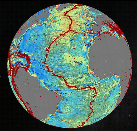
All data collected will be compiled into the free, publicly available GEBCO Grid. A primary goal of the Seabed 2030 project is to create a single map like this GEBCO Grid in which to consolidate all the world’s bathymetric data.
The newly forged partnership between Seabed 2030 and the U.S. seagoing scientific nonprofit Global Oceans promises to further the progress towards the goal of an accurate map of the oceans in a number of ways.
Global Oceans CEO and founder biologist Jim Costopulos explained, “Accessing high-resolution bathymetric data is essential to our projects, and we look forward to supporting Seabed 2030’s efforts.
To accomplish the seafloor mapping, Global Oceans plans to make available its 6,000-meter Ocean Explorer 6000 towed system to be re-built with multibeam sonar.
The two organizations will explore opportunities to co-finance extended mapping on Global Oceans’ projects. And Global Oceans will support new Seabed 2030-related projects on MARV vessels, Costopulos said.
MARV, or Modular Adaptive Research Vessel, is an operational model developed by Global Oceans allowing for the mobilization of modular workspaces and resources for scientific research on time-chartered ships.
This model makes use of the massive fleet of Offshore Service Vessels, OSVs, that remain unused around the world which can be fitted with scientific tools necessary for data collection, contributing to Seabed 2030’s goal.
The Ocean Explorer 6000 is a towed vehicle which can be deployed from a MARV OSV. Following its reconstruction with the state-of-the-art Multibeam Echo Sounder and additional upgrades to its imagery technology, this remotely operated vehicle will be capable of rendering high resolution images of broader sections of the seafloor.
Costopulos said, “We believe that in order to undertake meaningful action to tackle the impact of climate change and human activity we need to accelerate our scientific understanding of the ocean at a global scale and so we wholly subscribe to Seabed 2030’s mission to map the global seabed.”
Beyond satisfying human curiosity, a detailed map of the world’s ocean floor offers many practical benefits. A comprehensive map of the benthic world would help us identify ecological hotspots which are typically present at seamounts. This knowledge would allow for better management of fisheries and could direct conservation efforts.
Understanding the underwater topography will also further human comprehension of marine life below the surface.
Better ocean floor maps would also enhance our understanding of oceanic currents which transport sediments and nutrients and regulate the climate, which will determine how drastic the effects of climate change are.
They could also help us to predict how sea-level rise will occur in different places, allowing us to better prepare. Accurate bathymetric maps of the oceans could allow us to model where and how hard tidal waves are likely to strike land.
The technology sector also stands to gain as an accurate topographical map is essential for laying submarine cables and in the development of Wave Energy Conversion technology. Wave energy converters harvest incoming wave energy, changing the energy of a moving ocean wave into useable mechanical or electrical energy.
Ashley Chappell, integrated ocean and coastal mapping coordinator for the National Oceanic and Atmospheric Administration, explained the many uses for bathymetric maps, saying, “Data is used in coastal ocean science, habitat characterization, wave models, flooding models, wind energy development, all kinds of things.”
Despite the numerous applications for bathymetric data in many fields of scientific study, in 2017 only six percent of the seafloor was mapped to modern standards. By June 2021, Seabed 2030 had surpassed the 20 percent mark.
Although progress has been made, Seabed 2030 still faces a daunting task. To put the enormity of the project into perspective, Jaime Micheal-Phillips, Seabed 2030 project director and a former Royal Navy officer, said there remains, “An area about twice the size of Mars that we have to capture in the next decade.”
Collecting the enormous amount of data necessary to complete the map depends on efforts by marine research organizations, governments, maritime industries, and private boat owners who can attach data loggers to their existing sonar equipment.
Much of the data required for the GEBCO Grid has already been collected by private, government, and corporate entities but is not in the public domain. These entities contributing their data to the Seabed 2030 project is an important part of project completion.
Other strategies for collecting data include the use of uncrewed vehicles, and switching traditional routes taken by ships, which was effective in mapping much of the Drake Passage between South America and Antarctica.
Dan Hook, the managing director of Ocean Infinity, a UK-US marine robotics company developing remotely operated vehicles, ROVs, believes that cheap underwater unmanned vehicles may be key to surveying the more remote reaches of the ocean.
Hook conveyed the lack of pressure beyond the scientific community for accurate maps of remote stretches of ocean. “When you look at the mapping of the seabed in areas closer to shore, you see the business case very quickly. Whether it’s for wind farms or cable-laying – there are lots of people that want to know what’s down there. But when it’s those very remote areas of the planet, the case then is really only a scientific one.”
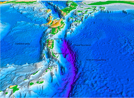
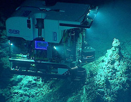
(Image courtesy the U.S. Geological Survey via University of Hawaii)
A far more controversial use for bathymetric data is in the mining of polymetallic nodules from the bottom of the ocean and the stripping of mineral-rich crust from seamounts.
Deeply embedded in seafloor ecosystems are critical minerals such as copper, cobalt, nickel and manganese.
Under the UN Convention on the Law of the Sea, UNCLOS, much of the seabed is “the common heritage of mankind.” Still, to date, only private exploratory investigations into the extraction of polymetallic nodules have taken place because the International Seabed Authority, ISA, has yet to establish regulations.
Still, six months ago, the small Pacific island nation of Nauru invoked the “Two Year Rule” meaning that the ISA must set regulations for the incoming wave of seabed mining within 18 months from today.
Many conservation groups stand in opposition to the potential mining, including the Deep Sea Conservation Coalition, an international alliance of more than 90 non-governmental organizations fighting for fragile ecosystems on the high seas.
There is a real possibility that deep-sea mining will soon be permitted. Exploratory contracts already have been issued for over 1.3 million square kilometers of the high seas outside national jurisdiction by the International Seabed Authority. The total area affected would be far larger, warns the DSCC.
The areas of the deep sea where these contracts have been issued support some of the most biodiverse and scientifically important ecosystems on Earth.
The DSCC argues that deep-sea mining will be impossible to monitor and is likely to be very destructive of the target ecosystems.
Scientists have warned that deep-sea mining would cause permanent loss of biodiversity in the deep sea but the scale of the loss is currently unknown.
Nauru and others involved in the mining projects retort that these minerals are essential in the production of electric car batteries that could be used to usher in a new era of green transport technology.
Although oceans cover 71 percent of the planet and constitute 99 percent of the space suitable for life, they remain mostly uncharted waters.
Seabed 2030 Project Director Jamie McMichael-Phillips emphasized the necessity of mapping the entire ocean floor, saying, “A complete map of the seabed will enable us to make informed decisions which can safeguard the future of our planet.”
He praised Seabed 2030’s latest partner, saying, “Global Oceans recognizes this and the fundamental role the oceans play in sustaining human life. We are, therefore, delighted to announce this new partnership as we make headway with our goal of the definitive map of the ocean floor by the end of this decade.”
McMichael-Phillips remains optimistic that with the help of a great collaboration amongst governments, companies, and private contributors from around the world, they will accomplish their goal.
“I am confident, but to do it we will need partnerships. We need governments, we need industry, we need academics, we need philanthropists, and we need citizen scientists,” McMichael-Phillips said. “We need all these individuals to come together if we’re to deliver an ocean map that is absolutely fundamental and essential to humankind.”
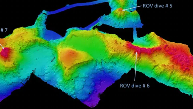
Featured image: A map of the ocean floor near the Keli Ridge in the western tropical Pacific Ocean, showing the sites of three ROV data-seeking dives. (Image courtesy NOAA Office of Ocean Exploration and Research, 2017 Laulima O Ka Moana)
© 2022, Environment News Service. All rights reserved. Content may be quoted only with proper attribution and a direct link to the original article. Full reproduction is prohibited.