COLLEGE PARK, Maryland, May 25, 2025 (ENS) – Bring in the lawn furniture, folks, and bar the doors and windows. There is an 85 percent chance that the countries and U.S. states bordering the Atlantic Ocean are in for a difficult “above-normal” hurricane season this year, U.S. National Weather Service experts at the Climate Prediction Center are warning. They put the chance of a “near-normal” hurricane season at just 10 percent, and a “below-normal” hurricane season in the Atlantic basin at five percent.
High ocean heat content and the anticipated development of La Niña are expected to fuel an above average hurricane season in the North Atlantic this year, according to the U.S. National Oceanic and Atmosphere Administration, NOAA.
Before a system forms, NOAA’s National Hurricane Center, NHC, issues Tropical Weather Outlooks every six hours to discuss areas of disturbed weather and their potential for development for the next seven days. The Tropical Weather Outlook is issued routinely from May 15 until the end of the 2024 hurricane season on November 30.
The National Weather Service, a NOAA agency, is forecasting between 17 to 25 total named storms this season with winds of 39 mph or higher.
Of that total, eight to 13 are forecast to become hurricanes with winds of 74 mph or higher, and there will likely be four to seven major hurricanes with winds of 111 mph or higher, classed in categories 3, 4, and 5.
“Severe weather and emergencies can happen at any moment, which is why individuals and communities need to be prepared today,” said FEMA Deputy Administrator Erik Hooks. “Already, we are seeing storms move across the country that can bring additional hazards like tornadoes, flooding and hail. Taking a proactive approach to our increasingly challenging climate landscape today can make a difference in how people can recover tomorrow.”
NOAA’s outlook is for overall seasonal activity and is not a landfall forecast. In addition to the Atlantic seasonal outlook, NOAA also issues seasonal hurricane outlooks for the eastern Pacific, central Pacific and western north Pacific hurricane basins.
NOAA’s Climate Prediction Center will update the 2024 Atlantic seasonal outlook in early August, prior to the historical peak of the season.
Forecasting the hazards of a hurricane and their potential impacts starts with data. Hurricane Specialists at NOAA’s National Hurricane Center analyze satellite imagery, other observations, and computer models to make forecast decisions and create hazard information for emergency managers, media and the public for hurricanes, tropical storms and tropical depressions.
Key data come from NOAA satellites that orbit the earth, continuously observing tropical cyclones from start to finish. Polar-orbiting satellites fly over the storm about twice a day at a lower altitude, carrying microwave instruments that reveal storm structure.

If there’s a chance the cyclone will threaten land, the National Hurricane Center, NHC, sends U.S. Air Force Reserve and NOAA Hurricane Hunter aircraft to fly through the storm to take detailed observations.
NHC’s Hurricane Specialists analyze a variety of computer models to help forecast tropical cyclones. Each storm is different, and no one model is right every time, so the specialists’ experience with these different models is crucial to coming up with the best forecast. On average the NHC forecasts are more consistent and have lower errors than the individual global models used in track forecasting.
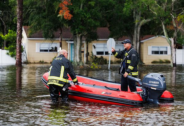
These storms can be destructive in the extreme, even deadly, notes the World Meteorological Organization, WMO.
“It takes just one landfalling hurricane to set back years of socio-economic development. For example Hurricane Maria in 2017 cost Dominica 800 percent of its Gross Domestic Product. Early warnings by the WMO community and improved disaster risk management have dramatically reduced fatalities, but Small Island Developing States in the Caribbean still suffer disproportionately,” said WMO Deputy Secretary-General Ko Barrett.
“This is why WMO and its partners have prioritized early warning action in small islands under the international Early Warnings For All initiative and will showcase the need for more coordinated and targeted investment in early warning systems at the forthcoming International Conference on Small Island Developing States,” said Barrett, who coordinates WMO Early Warnings for All activities.
“We need to be especially vigilant this year due to near-record ocean heat in the region where Atlantic hurricanes form and the shift to La Niña conditions, which together create the conditions for increased storm formulation,” Barrett warned.
NOAA 2024 Atlantic Hurricane Season Outlook:
- – Season probability: 85 percent Above normal, 10 percent Near normal; 5 percent Below normal.
- – Named storms: 7-25; Hurricanes: 8-13; Major hurricanes: 4-7.
Forecasters say they have a 70 percent confidence in these ranges. So that U.S. residents and visitors can be prepared, NOAA offers these resources.
Visit hurricanes.gov and follow @NWS and @NHC_Atlantic on X, formerly Twitter.
The Atlantic hurricane season lasts from June 1 to November 30 and is carefully monitored by the World Meteorological Organization Tropical Cyclone Programme. There have now been eight consecutive years of above average activity. The last below normal season was in 2015.
The upcoming Atlantic hurricane season is expected to have above-normal activity due to a confluence of factors, including near-record warm ocean temperatures in the Atlantic Ocean, development of La Niña conditions in the Pacific, reduced Atlantic trade winds and less wind shear, all of which tend to favor tropical storm formation.
“With another active hurricane season approaching, NOAA’s commitment to keeping every American informed with life-saving information is unwavering,” said NOAA Administrator Rick Spinrad, Ph.D.
“AI-enabled language translations and a new depiction of inland wind threats in the forecast cone are just two examples of the proactive steps our agency is taking to meet our mission of saving lives and protecting property,” Dr. Spinrad said.
As one of the strongest El Ninos ever observed nears its end, NOAA scientists predict a quick transition to La Niña conditions, which are conducive to Atlantic hurricane activity because La Niña tends to lessen wind shear in the tropics.
At the same time, abundant oceanic heat content in the tropical Atlantic Ocean and Caribbean Sea creates more energy to fuel storm development.
This hurricane season also features the potential for an above-normal west African monsoon, which can produce African easterly waves that seed some of the strongest and longest-lived Atlantic storms.
Finally, light trade winds allow hurricanes to grow in strength without the disruption of strong wind shear, and also minimize ocean cooling.
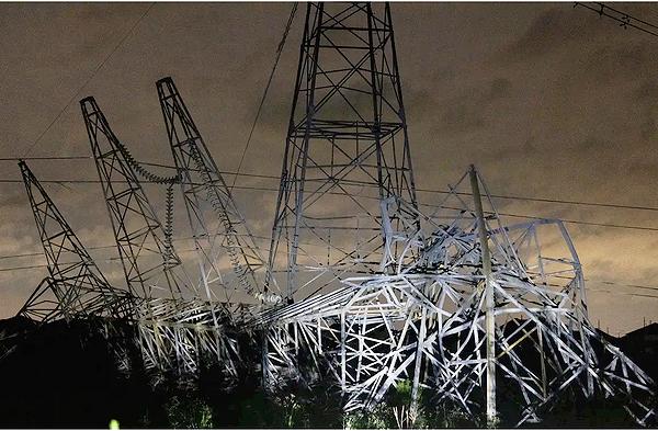
Human-caused climate change is warming our ocean globally and in the Atlantic basin, and melting ice on land, leading to sea level rise, which increases the risk of storm surge. Sea level rise represents a clear human influence on the damage potential from a given hurricane, NOAA observes.
NOAA Upgrades Communications This Season
NOAA expects to make major improvements to its forecast communications, decision support and storm recovery efforts this season.
- – The National Hurricane Center will expand its offering of Spanish language text products to include all public advisories, the tropical cyclone discussion, the tropical cyclone update and key messages in the Atlantic basin.
- – Beginning on or around August 15, NHC will start to issue an experimental version of the forecast cone graphic that includes a depiction of inland tropical storm and hurricane watches and warnings in effect for the continental United States. Research indicates that the addition of inland watches and warnings to the cone graphic will help communicate inland hazards during tropical cyclone events without overcomplicating the current version of the graphic.
- – This season, the NHC will be able to issue U.S. tropical cyclone watches and warnings with regular or intermediate public advisories. This means that if updates to watches and warnings for storm surge or winds are needed, the NHC will be able to notify the public in an intermediate advisory instead of having to wait for the next full advisory issued every six hours.
New tools for hurricane analysis and forecasting this year include:
- – Two new forecast models developed by NOAA researchers that will go into operation this season: The Modular Ocean Model or MOM6 will be added to the Hurricane Analysis and Forecast System to improve the representation of the key role the ocean plays in driving hurricane intensity. Another model, SDCON, will predict the probability of tropical cyclone rapid intensification.
- – NOAA’s new generation of Flood Inundation Mapping, made possible through President Biden’s Bipartisan Infrastructure Law, will provide information to emergency and water managers to prepare and respond to potential flooding and help local officials better prepare to protect people and infrastructure.
- – NOAA’s Weather Prediction Center, in partnership with the NHC, will issue an experimental rainfall graphic for the Caribbean and Central America during the 2024 hurricane season. This graphic provides forecast rainfall totals associated with a tropical cyclone or disturbance for a specified time period.
System upgrades now in operation include:
- – NOAA is upgrading its observing systems critical in understanding and forecasting hurricanes. These projects will provide more observations of the ocean and atmosphere in the Caribbean, the Gulf of Mexico, on the U.S. East Coast and in the tropical Atlantic.
- – NOAA’s National Data Buoy Center recently upgraded many coastal weather buoys in the tropical western Atlantic and Caribbean to include time of occurrence and measurements of one-minute wind speed and direction, five-second peak wind gust and direction and lowest one-minute barometric pressure to support tropical cyclone forecasting.
- – New this year, NOAA will gather additional observations using Directional Wave Spectra Drifters deployed from the NOAA P-3 hurricane hunter aircraft and in the vicinity of Saildrones, uncrewed surface vehicles which will be deployed at the start of the hurricane season, providing one-minute data in real time. NOAA plans to deploy 11-12 Saildrones in 2024.
- – Starting in June, dozens of observational underwater gliders are planned to deploy in waters off the Caribbean, Gulf of Mexico and the eastern U.S. coast. Additionally, a new lightweight dropsonde called Streamsonde will be deployed into developing tropical storms, making multiple real-time observations to collect valuable wind data.
- – The CHAOS (Coordinated Hurricane Atmosphere-Ocean Sampling) research experiment aims to improve the understanding of air-sea interactions, providing sustained monitoring of key ocean features.
The names of hurricanes are provided by the World Meteorological Organization. Atlantic hurricane Season Names for 2024 are: Alberto, Beryl, Chris, Debby, Ernesto, Francine, Gordon, Helene, Isaac, Joyce, Kirk, Leslie, Milton, Nadine, Oscar, Patty, Rafael, Sara, Tony, Valerie and William.
Featured image: Image equipment onboard NOAA’s GOES East satellite captured this image of Hurricane Lee churning over the Atlantic, northeast of Puerto Rico, as well as Tropical Storm Margot farther east, as the sun rose overhead, September 11, 2023, at 7:30 a.m. EDT (Photo courtesy National Oceanic and Atmospheric Administration, NOAA)