COLLEGE PARK, Maryland, May 21, 2020 (ENS) – There is a 60 percent chance of an above-normal 2020 Atlantic hurricane season, with three to six major hurricanes, forecasters with NOAA’s Climate Prediction Center, announced today ahead of the Atlantic hurricane season – June 1 through November 30.
The Climate Prediction Center, a division of the National Weather Service, says there is a 60 percent chance of an above-normal season, a 30 percent chance of a near-normal season, and only a 10 percent chance of a below-normal season.
They predict a likely range of 13 to 19 named storms with winds of 39 miles per hour or higher.
Of these, six to 10 could become hurricanes, packing winds of 74 mph or higher, and of these, there could be three to six major hurricanes. A major hurricane is one that is Category 3 or higher, with 115-plus-mph winds, on the Saffir-Simpson Hurricane Wind Scale.
NOAA provides these ranges with 70 percent confidence. NOAA’s outlook is for overall seasonal activity and is not a landfall forecast.
An average hurricane season produces 12 named storms, of which six become hurricanes, including three major hurricanes.
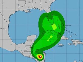
A summary infographic showing hurricane season probability and numbers of named storms predicted from NOAA’s 2020 Atlantic Hurricane Season Outlook.
“NOAA’s analysis of current and seasonal atmospheric conditions reveals a recipe for an active Atlantic hurricane season this year,” said Neil Jacobs, PhD, acting NOAA administrator. “Our skilled forecasters, coupled with upgrades to our computer models and observing technologies, will provide accurate and timely forecasts to protect life and property.”
Colorado State University Forecasters Agree
Forecasters in the Department of Atmospheric Science at Colorado State University – Philip Klotzbach, Michael Bell, and Jhordanne Jones – on April 2 predicted a similar above-normal Atlantic hurricane season with 16 named storms, eight hurricanes and four major hurricanes.
“We anticipate an above-average probability for major hurricanes making landfall along the continental United States coastline and in the Caribbean,” they wrote. “As is the case with all hurricane seasons, coastal residents are reminded that it only takes one hurricane making landfall to make it an active season for them. They should prepare the same for every season, regardless of how much activity is predicted.”
The Colorado State team gives these probabilities for at least one major hurricane landfall on U.S. coastal areas:
1) Entire continental U.S. coastline – 69 percent (average for last century is 52 percent)
2) U.S. East Coast including the Florida Peninsula – 45 percent (average for last century is 31 percent)
3) Gulf Coast from the Florida Panhandle westward to Brownsville, Texas – 44 percent (average for last century is 30 percent)
Carlos Castillo, acting deputy administrator for resilience at the Federal Emergency Management Agency, FEMA, had a warning for anyone who might have to evacuate when a hurricane looms. “Social distancing and other CDC guidance to keep you safe from COVID-19 may impact the disaster preparedness plan you had in place, including what is in your go-kit, evacuation routes, shelters, and more,” he said.
“With tornado season at its peak, hurricane season around the corner, and flooding, earthquakes, and wildfires a risk year-round, it is time to revise and adjust your emergency plan now. Natural disasters won’t wait, so I encourage you to keep COVID-19 in mind when revising or making your plan for you and your loved ones, and don’t forget your pets,” Castillo advised. “An easy way to start is to download the FEMA app today.”
Climate Factors Drive 2020 Hurricane Season

The combination of several climate factors is driving the strong likelihood for above-normal activity in the Atlantic this year, according to the Climate Prediction Center as well as the Colorado State atmospheric scientists.
The warming phase of sea temperature oscillation, El Nino, is expected to either remain neutral or to trend toward the cooling phase, La Nina, which means there will not be an El Nino present to suppress hurricane activity.
In addition, warmer-than-average sea surface temperatures in the tropical Atlantic Ocean and the Caribbean Sea, coupled with reduced vertical wind shear, weaker tropical Atlantic trade winds, and an enhanced west African monsoon all increase the likelihood for an above-normal Atlantic hurricane season.
Similar conditions have been producing more active seasons since the current high-activity era began in 1995.
“As Americans focus their attention on a safe and healthy reopening of our country, it remains critically important that we also remember to make the necessary preparations for the upcoming hurricane season,” said Secretary of Commerce Wilbur Ross, who has jurisdiction over the National Weather Service. “Just as in years past, NOAA experts will stay ahead of developing hurricanes and tropical storms and provide the forecasts and warnings we depend on to stay safe.”
Scientific Upgrades Aim to Improve Modeling
To improve critical services during the hurricane season, NOAA will upgrade the hurricane-specific Hurricane Weather Research and Forecast system (HWRF) and the Hurricanes in a Multi-scale Ocean coupled Non-hydrostatic model (HMON) models this summer.
HWRF will incorporate new data from satellites and radar from NOAA’s coastal Doppler data network to help produce better forecasts of hurricane track and intensity during the critical watch and warning time frame.
HMON enhancements include higher resolution, improved physics, and coupling with ocean models.
As the hurricane season gets underway, NOAA will begin feeding data from the COSMIC-2 satellites into weather models to help track hurricane intensity and boost forecast accuracy. COSMIC-2 provides data about air temperature, pressure, and humidity in the tropical regions of Earth, where hurricane and tropical storm systems form.
Also during the 2020 hurricane season, NOAA and the U.S. Navy will deploy a fleet of autonomous diving hurricane gliders to observe conditions in the tropical Atlantic Ocean and the Caribbean Sea in areas where hurricanes have historically traveled and intensified.
Copyright Environment News Service (ENS) 2020. All rights reserved.
© 2020, Environment News Service. All rights reserved. Content may be quoted only with proper attribution and a direct link to the original article. Full reproduction is prohibited.