MIAMI, Florida, November 4, 2020 (ENS) – Slow-moving, wet and windy, Hurricane Eta made landfall south of Puerto Cabezas, on the coast of Nicaragua as a Category 4 hurricane on Tuesday afternoon. Eta had maximum sustained winds near 140 mph at landfall, but by Wednesday morning the winds had dropped to tropical storm status with 70 mph winds, according to the U.S. National Hurricane Center.
The death toll rose to three in Honduras and Nicaragua on Wednesday one day after Hurricane Eta made landfall. Torrential rainfall caused major flooding, leading to dramatic rescues. Widespread power outages and damaged infrastructure from the overflowing rivers and landslides have devastated the two countries.
Two Nicaragua residents perished in a landslide while working in a mine in Bonanza, the Associated Press reports.
In Honduras, pummeling rains set off a mudslide, claiming the life of a 12-year-old girl in San Pedro Sula, Director of the Honduras Emergency Management Agency Guillermo Gonzalez told the AP.
Honduran authorities declared a National Emergency and issue a red alert for the entire country on Wednesday due to the devastating effects of Hurricane Eta.
More than 2,000 people were evacuated in Honduras because of Eta, the country’s Permanent Contingency Commission reported Wednesday. The storm destroyed bridges, roads and more than 330 homes, the commission said.
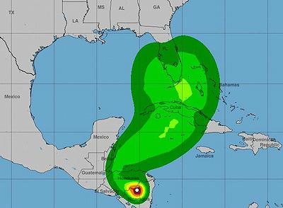
The National Hurricane Center has forecast that Eta will re-enter the Caribbean Sea on Friday as a tropical storm, cross Cuba and approach the coast of southern Florida and the Florida Keys near Key West.
The South Florida Water Management District (SFWMD) is prepared for potentially heavy rain from Tropical Storm Eta as it is forecasted to approach South Florida this weekend.
Eta is projected to move north up Florida’s state’s Gulf Coast early next week, but still forecasters warn that the big, wet storm could dump heavy rains and cause flooding on the state’s southeast coast as well.
The South Florida Water Management District (SFWMD) has prepared for potentially heavy rain from Tropical Storm Eta this weekend by lowering canal levels to accommodate more water; staffing pump stations and control rooms to manage water; coordinating response with local governments and drainage districts; and preparing to use projects and infrastructure to store excess stormwater.
Although the coastal warnings have been discontinued, the governments of Nicaragua and Honduras continue to issue warnings on heavy rain and flooding in those two Central American countries, The forecasters advised Nicaragua, Honduras, Belize, western Cuba, and the Cayman Islands to monitor the progress of this storm.
Forecasters at the National Hurricane Center expect Eta to produce the following rainfall amounts through Sunday morning:
Much of Nicaragua and Honduras: 15 to 25 inches (380 to 635 mm), isolated maximum totals of 40 inches (1000 mm) in northeast Nicaragua and eastern Honduras.
Eastern Guatemala and Belize: 10 to 20 inches (255 to 510 mm), isolated amounts of 25 inches (635 mm).
Portions of Panama and Costa Rica: 10 to 15 inches (255 to 380 mm), isolated amounts of 25 inches (635 mm).
El Salvador and southeast Mexico: 5 to 10 inches (125 to 255 mm), isolated amounts of 15 inches (380 mm).
Jamaica, Southern Haiti, the Cayman Islands: An additional 3 to 5 inches (75 to 125 mm), isolated storm totals of 15 inches (380 mm).
This rainfall will lead to catastrophic, life-threatening flash flooding and river flooding, along with landslides in areas of higher terrain of Central America. Flash flooding and river
flooding will be possible across Jamaica, southeast Mexico, El Salvador, southern Haiti, and the Cayman Islands, the Hurricane Center warns.
Storm surge water levels along the coasts of Nicaragua and Honduras should gradually decrease today, but this week is not the time to surf Central American waters.
Forecasters warns that swells generated by Eta are expected to affect portions of the coast of Central America and the Yucatan Peninsula of Mexico during the next few days. These swells are likely to cause life-threatening surf and rip current conditions.
© 2020, Environment News Service. All rights reserved. Content may be quoted only with proper attribution and a direct link to the original article. Full reproduction is prohibited.