
ANCHORAGE, Alaska, January 23, 2018 (ENS) – A massive magnitude 7.9 earthquake struck off the Alaskan coast southeast of Kodiak Island in the Gulf of Alaska at 12:31 this morning, local time.
The center of the quake was located 175 miles southeast of Kodiak City. Scientists with the U.S. Geological Survey at first measured the quake at a magnitude of 8.2, but several hours later reduced that measure of strength to magnitude 7.9.
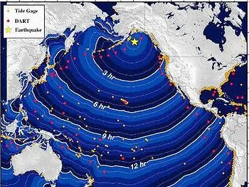
A tsunami alert was immediately issued from Alaska down the West Coast of North America to California and west to the Hawaiian Islands.
The tsunami alert activated emergency warnings around Alaska. Alerts were issued in coastal areas for residents to move to higher ground. Sirens roused residents of Kodiak and Homer, and people were evacuated from Sitka to Seward. There was no tsunami alert in Anchorage.

Two hours later the tsunami warning was still in effect for south Alaska and the Alaska Peninsula and Pacific coasts from Hinchinbrook Entrance, Alaska, 90 miles east of Seward, to Chignik Bay, Alaska.
A tsunami was generated by the quake, but waves never reached a height more than one foot. The coasts at Kodiak, Seward, Old Harbor, Sitka and Yakutat were affected.
All warnings, alerts and watches were canceled just after 4 am, and there were no reports of damage.
The U.S. Geological Survey says today’s earthquake occurred as the result of strike slip faulting within the shallow lithosphere of the Pacific plate.
At the location of the earthquake, the Pacific plate is converging with the North America plate at a rate of approximately 59 mm/yr towards the north-northwest.
The Pacific plate subducts beneath the North America plate at the Alaska-Aleutians Trench, about 90 km to the northwest of today’s earthquake, the USGS said.
The location and mechanism of today’s earthquake are consistent with it occurring on a fault system within the Pacific plate before it subducts, rather than on the plate boundary between the Pacific and North America plates further to the northwest, USGS scientists explained.
While commonly plotted as points on maps, earthquakes of this size are better described as slip over a larger fault area. Strike-slip-faulting events of the size of the January 23, 2018 earthquake are typically about 230 kilometers in length and 30 km in width.
Large earthquakes are common in the Pacific-North America plate boundary region south of Alaska. The USGS records show that over the preceding century, 11 other M7+ earthquakes have occurred within 600 km (400 miles) of today’s earthquake.
Most of these have occurred on the subduction zone interface between the two plates, to the north and northwest of today’s earthquake, including the M 9.2 Great Alaska earthquake of March 1964. The hypocenter of the 1964 event was located about 550 km to the north of the January 23rd earthquake, and the rupture of that event broke much of the shallow subduction zone interface over several hundreds of kilometers.
To the southeast of the Alaska Trench, two large (M 7.9 and M 7.8) strike slip earthquakes occurred in November 1987 and March 1988, respectively, several hundreds of kilometers to the east of today’s quake.
© 2018, Environment News Service. All rights reserved. Content may be quoted only with proper attribution and a direct link to the original article. Full reproduction is prohibited.