WASHINGTON, DC, September 9, 2022 (ENS) – Where’s the fire? Where’s the flood? For the first time, an online live climate impact dashboard is allowing people to see extreme weather, drought, wildfire and other climate change hazards that their locations are facing in the short term, with more maps showing how each community could be affected in the future.
A project of the Biden-Harris Administration, the new Climate Mapping for Resilience and Adaptation, CMRA, portal will help governments and leaders at all levels better track real-time impacts and access federal resources for long-term planning.
Right now, Americans are feeling the intensifying impacts of the climate crisis: extreme heat across the country, including the dangerous “heat dome” gripping California this week; record-breaking floods across the South and Midwest; Western drought straining the water supplies that millions depend on; and more wildfires across the West threatening more communities.
Last year, the 20 largest climate-related disasters alone took hundreds of lives, caused untold hardships, and racked up more than US$150 billion in damages.
In addition to real-time data about extreme weather events, the portal helps communities understand their historic and future exposure to a range of climate impacts.
The new portal is an outgrowth of a National Climate Task Force initiative to provide more accessible climate information and decision tools, as directed by President Joe Biden in his Executive Order Tackling the Climate Crisis at Home and Abroad issued on January 27, 2021, in the very early days of the Biden presidency.
The day he signed the Order, President Biden made it clear that grappling with climate change would be a priority for his administration.

“United States international engagement to address climate change – which has become a climate crisis – is more necessary and urgent than ever,” Biden’s Order states. “The scientific community has made clear that the scale and speed of necessary action is greater than previously believed. There is little time left to avoid setting the world on a dangerous, potentially catastrophic, climate trajectory. Responding to the climate crisis will require both significant short-term global reductions in greenhouse gas emissions and net-zero global emissions by mid-century or before.”
“It is the policy of my Administration that climate considerations shall be an essential element of United States foreign policy and national security,” the Order states.
This initiative is showing up online. In 2021 the National Oceanic and Atmospheric Administration, NOAA, launched a redesigned Climate.gov, and this year the National Integrated Heat Health Information System launched the new Heat.gov, using data sources that are now incorporated into the CMRA portal.
The new portal brings together multiple federal information sources and funding opportunities to help communities better prepare for and respond to climate impacts, including historic resilience funding from the Bipartisan Infrastructure Law for states and communities across the country.
The Climate Mapping for Resilience and Adaptation portal is a first-of-its kind hub that the White House says will continue to evolve to meet community needs. It now includes:

Real-time monitoring dashboard: To help track the climate-related hazards that are affecting communities day-by-day, the dashboard brings together maps showing areas currently under extreme heat advisories, drought conditions, and inland and coastal flooding warnings. It shows the locations of active wildfires and areas of poor air quality they produce.
Assessments of future local climate exposure: The portal’s Assessment Tool provides hazard reports on heat, drought, and flooding down to the census tract level, including projections of future impacts in both low and high-emissions scenarios, based on climate models used in the U.S. National Climate Assessment.
This interactive application will help local resilience planners and other users understand how future temperature, precipitation, and flooding conditions may impact their community in the near-term and by mid- and late-century.
Building on Climate Data Efforts Across the U.S. Government
The portal centralizes federal data, programs, and funding opportunities that are available to support resilience efforts, including resources for extreme heat, drought, wildfire, flooding, and coastal inundation and sea level rise. The CMRA Assessment Tool will also help state, local, tribal, and territorial governments develop data-driven proposals to access federal funding.
The Assessment Tool integrates information from federal initiatives including:
Climate and Economic Justice Screening Tool: As part of the Biden-Harris Administration’s Justice40 Initiative, this screening tool identifies disadvantaged communities that are marginalized, underserved, and overburdened by pollution. The Assessment Tool identifies these census tracts as well, helping planners at all levels of government prioritize equity as they design and implement resilience projects.
Building Code Adoption Tracking Portal: As part of the administration’s National Initiative to Advance Building Codes, FEMA continues to update its Building Code Adoption Tracking portal on the status of state, local, tribal, and territorial building codes and whether these codes provide resistance to hazards such as floods, hurricanes, and tornados. Information on whether an area is covered by a hazard-resistant building code is shown in the Assessment Tool.
Updated Sea Level Rise data: Earlier this year, the administration issued the 2022 Sea Level Rise Technical Report, with updated sea level rise projections out to the year 2150 for all U.S. states and territories. This data is incorporated throughout the portal’s resources on coastal inundation.
NOAA is using resources from the Bipartisan Infrastructure Law to enhance a wide array of climate data and services, including flood forecasting, soil moisture monitoring, and wildfire prediction and detection.
Additionally, the Inflation Reduction Act passed this summer provides resources for NOAA to improve computing capacity, forecasting, and research for weather and climate impacts, as well as funding for the White House Council on Environmental Quality to boost data collection on environmental harms and climate impacts.
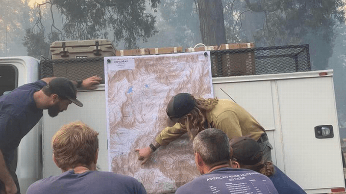
Featured image: The American River hotshot crew on the Tahoe National Forest studies a map of the Mosquito Fire. September 8, 2022 California (Photo by B. Blaine) Hotshot crews work on the most challenging fires. The U.S. Forest Service, National Park Service, Bureau of Land Management, Bureau of Indian Affairs, state and county agencies sponsor more than 100 Interagency Hotshots Crews, most in the western United States.
© 2022, Environment News Service. All rights reserved. Content may be quoted only with proper attribution and a direct link to the original article. Full reproduction is prohibited.