KINGSTON, Jamaica, October 28, 2025 (ENS) – The eye of the “extremely dangerous” Category 5 Hurricane Melissa is approaching western Jamaica at this moment, menacing the Caribbean island nation with catastrophic winds, flash flooding, and storm surge, warn the Meteorological Service of Jamaica and the U.S. National Hurricane Center, NHC. It is expected to be the strongest hurricane ever to make landfall in Jamaica since record-keeping began in 1851.
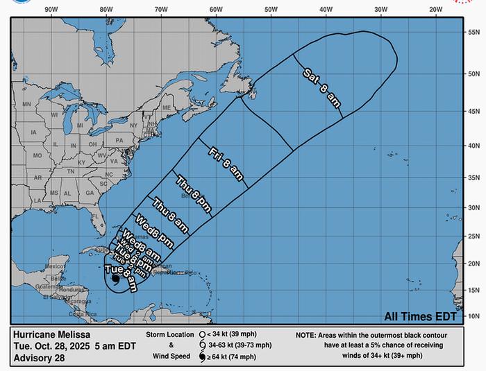
Melissa is moving toward the north-northeast near seven mph (11 km/h). A turn toward the northeast with an increase in forward speed is expected later today, followed by a faster northeastward motion on Wednesday and Thursday, the NHC predicts.
On the forecast track, the core of Melissa is expected to make landfall on Jamaica between East Westmoreland and Western St. Elizabeth during the next several hours, move across southeastern Cuba Wednesday morning, and move across the southeastern or central Bahamas later on Wednesday.
Maximum sustained winds are near 175 mph (280 km/h) with higher gusts. Melissa is a category 5 hurricane on the Saffir-Simpson Hurricane Wind Scale. the highest category on the Scale.
Melissa is expected to reach Jamaica and southeastern Cuba as an extremely dangerous major hurricane, and it will still be at hurricane strength when it moves across the southeastern Bahamas.
Hurricane-force winds extend outward up to 30 miles (45 km) from the center and tropical-storm-force winds extend outward up to 195 miles (315 km).
During the past few hours, Norman Manley International Airport in Kingston, on Jamaica’s south shore, reported a sustained wind of 43 mph (69 km/h) and a gust of 59 mph (93 km/h). Sangster International Airport in Montego Bay, on Jamaica’s north shore, reports sustained winds of 38 mph (61 km/h) and gusts of 54 mph (87 km/h).
A life-threatening storm surge is likely along the south coast of Jamaica today. Peak storm surge heights could reach nine to 13 feet above ground level, near and to the east of where the center of Melissa makes landfall. This storm surge will be accompanied by large and destructive waves.
On the northwest coast of Jamaica, near Montego Bay, there is the possibility of two to four feet of storm surge above ground level, forecasters warn.
A storm surge of up to 13 feet (four meters) is expected along coastal Kingston, which hosts Jamaica’s main international airport and power plants.
Melissa is expected to bring rainfall of 15 to 30 inches to portions of Jamaica and additional rainfall of six to 12 inches for southern Hispaniola through Wednesday, with 40 inches possible. Catastrophic flash flooding and numerous landslides are likely, NHC predicts.
For eastern Cuba, storm total rainfall of 10 to 20 inches, with local amounts to 25 inches, is expected into Wednesday resulting in life-threatening and potentially catastrophic flash flooding with numerous landslides.
Over the Southeastern Bahamas and the Turks and Caicos, rain is expected to develop later today and continue into Wednesday. Total rainfall of 5 to 10 inches is expected to result in areas of flash flooding.
For a complete depiction of forecast rainfall associated with Melissa, please see the U.S. National Weather Service Storm Total Rainfall Graphic.
Jamaica in Melissa’s Path, But Residents Slow to Evacuate
The hurricane is expected to make landfall today between East Westmoreland and Western St. Elizabeth, Jamaica’s two southwestern-most parishes.
All of these warnings sound life threatening, but despite Mandatory Evacuation Orders from the Jamaican Government, many residents want to stay in their homes.
Jamaica’s Prime Minister Dr. Andrew Holness is urging citizens to obey the legal directive.
“We have always had a very slow, if not non-response to the call for evacuation, and it is a balance between respecting the rights of persons to stay and protect their property and trying to balance the national good of saving lives and the expenditure of resources unnecessarily,” Prime Minister Holness said.
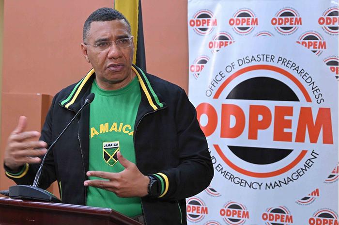
“I think generally we have struck the balance in favor of respecting the rights of citizens to stay where they are, though we give them the information for them to make the decision,” he said.
“We are in that zone where we have given the information; no one can say that the Government was not forward leaning in giving the information to persons who are in areas of risk. You have been warned, so it is now up to you to use that information to make the right decisions,” the prime minister said.
He explained that the Office of Disaster Preparedness and Emergency Management, ODPEM, as well as the Security Forces “…could very well go into some areas and effect… their evacuation of persons who are there.”
“If there were a catastrophic event and persons were there in the path of the catastrophe and we were still able to go, because it’s a big if; if we were still able to go, then the country, the Government and myself, I couldn’t sit by and see my citizens in danger and I am able to go and save them, even if they don’t want to be moved, and I don’t do it,” the prime minister reasoned.
“But I couldn’t do it unless it is within the law, and that is why we make the evacuation Orders, so that if that scenario were to materialize, within the law I’m acting, the compulsory evacuation orders have been put to ensure that there is a legal framework for the Government to act,” he said.
The mandatory Order will remain in place for the duration of the Declaration of the Threatened Area Order, which Prime Minister Holness declared over the island on Friday when Hurricane Melissa was slowly moving towards the island as a tropical storm.
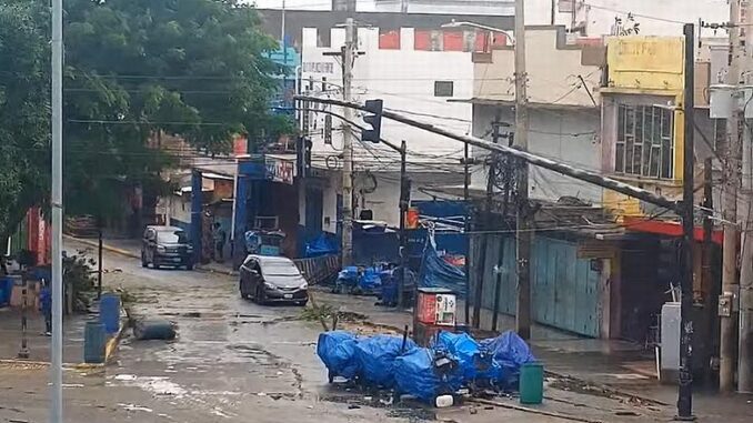
Featured image: Hurricane Melissa makes itself felt on West Parade Street, Downtown Kingston, Jamaica, October 28, 2025 (Screengrab from video courtesy See Jamaica via YouTube)
© 2025, Environment News Service. All rights reserved. Content may be quoted only with proper attribution and a direct link to the original article. Full reproduction is prohibited.