DENVER, Colorado, February 14, 2024 (ENS) – It’s Geo Week in Denver, where one of the world’s largest geospatial conferences is underway. As part of the gathering, on February 12, a group of Lidar enthusiasts celebrated the first World Lidar Day, marking this date as an annual celebration of the expanding world enabled by Light Detection and Ranging, LIDAR.
Lidar is a remote sensing technology that uses light in the form of a pulsed laser to determine the distance to an object by measuring the time it takes for that light to return to its sending point.
Lidar data are collected via air, land, and sea vessels, and the capability now is available on some smartphones.
Introduced in 2020, the LiDAR scanner is available on the Pro and Pro Max models of the iPhone 12, 13, 14, and 15, as well as some iPad Pro models from 2020 and later. Placed among the rear cameras, the scanner can detect objects up to five meters, or 16.5 inches.
Founding members of World Lidar Day are scientists and engineers with both public and private organizations, working collaboratively to raise awareness about the value of lidar. They include:
- – the U.S. Geological Survey,
- – National Oceanic and Atmospheric Administration’s National Geodetic Survey,
- – International Society for Photogrammetry and Remote Sensing,
- – American Society for Photogrammetry and Remote Sensing,
- – National Society of Professional Surveyors,
- – U.S. Army Corps of Engineers’ Joint Airborne Lidar Bathymetry Technical Center of Expertise,
- – U.S. Geospatial Intelligence Foundation,
- – Woolpert, the U.S. multinational architecture, engineering, geospatial and strategic consulting firm,
- – Hexagon, a Swedish reality capture technology company,
- – RIEGL, a lidar sensor manufacturer using advanced sensor fusion technology for reality capture
- – Teledyne Optech, a Canadian firm supplying airborne laser terrain mapping systems, airborne laser bathymetry, industrial and 3D imaging, and space lidar solutions, and
- – LIDAR Magazine.
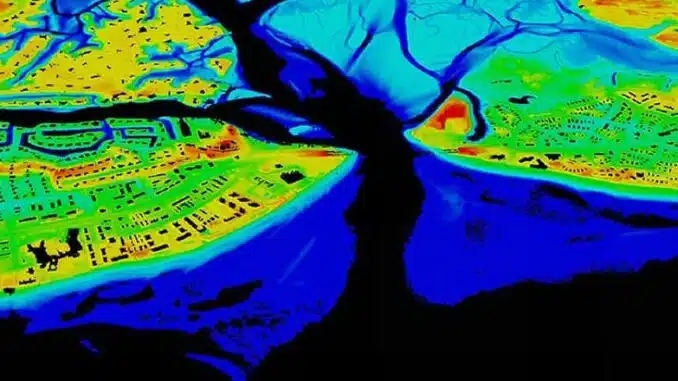
High-resolution lidar data are used to map and model the elevation of both natural and built environment, on land and underwater.
Two types of lidar exist. Topographic lidar uses a near-infrared laser to map the land, while bathymetric lidar uses water-penetrating green light to measure seafloor and riverbed elevations.
A lidar instrument has a laser, a scanner, and a specialized GPS receiver, explains NOAA, the U.S. National Oceanic and Atmospheric Administration.
NOAA scientists are using lidar to produce more accurate shoreline maps, and to make digital elevation models for use in geographic information systems used to assist in emergency response operations, among many other applications.
Lidar data sets for many coastal areas can be downloaded from NOAA’s Office for Coastal Management Digital Coast web portal.
Airplanes and helicopters are the most commonly used platforms for acquiring lidar data over broad areas. Light pulses plus other data gathered by the airborne system, generate precise, three-dimensional information about the shape of the Earth and its surface characteristics.
These data address worldwide needs for managing so many situations: emergency response, disaster mitigation, flood-risk management, coastal resilience, forestry management, water supply and quality management, infrastructure and construction management, transportation planning, the safe use and deployment of autonomous vehicles, aviation navigation and safety.
Lidar mapping also enables wildlife and habitat management, invasive species mitigation, critical mineral mapping and mining, agriculture and precision farming, and natural resources conservation.
Lidar Enables Driverless Cars
Data can be collected at varying levels of accuracy for a wide range of applications. For instance, lidar is changing the auto industry by enabling development of autonomous, self-driving vehicles.
Lidar systems create precise, detailed 3D maps of a vehicle’s surroundings, critical for accurate navigation in complex urban environments.
Lidar enables vehicles to detect and recognize obstacles in real-time. This is essential for avoiding collisions and ensuring the safety of passengers and pedestrians, and contributes to improved overall safety on the roads.
Ongoing advancements in lidar technology aim to make it more compact, cost-effective and robust. This will facilitate its integration into a broader range of vehicles, contributing to the widespread adoption of autonomous driving technology.
Lidar works with other sensors like cameras and radar to improve overall perception in a wide range of driving circumstances, from low light to bad weather. By providing a comprehensive and accurate view of the environment, lidar helps self-driving cars make informed decisions and navigate safely.
Due to its evolving benefits, ongoing returns on investment, and consistent increase in demand, the global lidar market reportedly reached $2.6 billion in 2023 and is expected to grow to more than $12 billion by 2032.
The founding members’ said in a statement that their intention with World Lidar Day is to “promote awareness of the technology and to develop an annual platform for learning and collaboration.” Any organization that develops or utilizes lidar is encouraged to promote February 12 as World Lidar Day. For information, visit lidarday.com.
To find Lidar information sources and data sets, go to the U.S. Geological Service page, “What is Lidar data and where can I download it?”
Featured image: A lidar map of Lynnhaven Inlet, Virginia. (Map courtesy U.S. National Ocean and Atmospheric Administration)
© 2024, Environment News Service. All rights reserved. Content may be quoted only with proper attribution and a direct link to the original article. Full reproduction is prohibited.