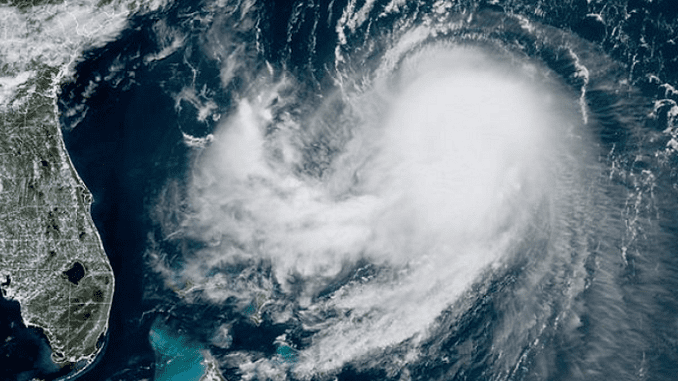
MIAMI, Florida, August 20, 2021 (ENS) – Hurricane Hunter Aircraft from NOAA and the U.S. Air Force Reserve flying into the midst of what is now Tropical Storm Henri off the coast of North Carolina report maximum sustained winds near 70 mph (110 km/h) with higher gusts.
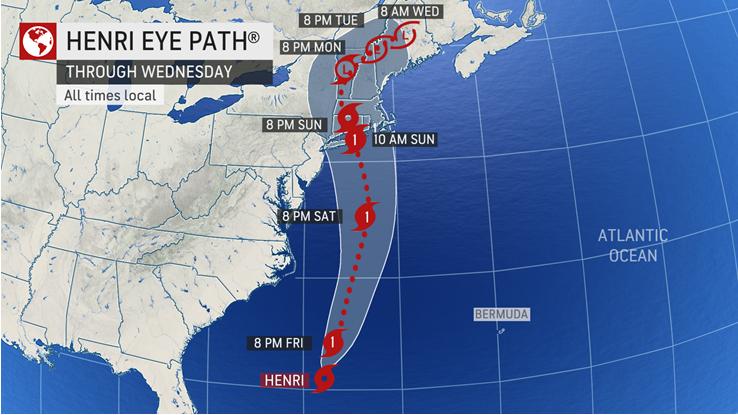
When the storm makes landfall somewhere on Long Island or in southern New England later this weekend, it’s expected to be a hurricane, packing winds stronger than 74 mph.
Strengthening is forecast during the next day or so, and Henri is expected to become a hurricane tonight or Saturday and be at or near hurricane strength when it touches land on Sunday.
Tropical-storm-force winds extend outward up to 115 miles (185 km) from the center of the storm.
Henri may produce rainfall amounts of three to six inches over Long Island and New England Sunday into Monday, with isolated maximum totals near 10 inches, says the National Weather Service, NWS.
Heavy rainfall from Henri could result in considerable flash, urban, and small stream flooding, along with the potential for widespread minor and isolated moderate river flooding, the NWS predicts.
The National Hurricane Center in Miami has issued a Hurricane Warning for…
- South shore of Long Island from Fire Island Inlet to Montauk Point
- North shore of Long Island from Port Jefferson Harbor to Montauk Point
- New Haven, Connecticut to west of Watch Hill, Rhode Island
A Hurricane Watch is in effect for…
- Watch Hill, Rhode Island to Sagamore Beach, Massachusetts
- Nantucket, Martha’s Vineyard, and Block Island
A Tropical Storm Warning is in effect for…
- Port Jefferson Harbor to west of New Haven, Connecticut
- South shore of Long Island from west of Fire Island Inlet to East Rockaway Inlet
A Tropical Storm Watch is in effect for…
- Manasquan Inlet, New Jersey to west of East Rockaway Inlet, New York, including New York City
Storm Surge Warnings have been issued for Long Island and shorelines from Greenwich, Connecticut to Chatham, Nantucket, Martha’s Vineyard, and Block Island, Massachusetts.
A Storm Surge Watch is in effect for Flushing, New York to west of Greenwich, Connecticut, Chatham to Sagamore Beach, Massachusetts, and Cape Cod Bay.
The deepest water will occur along the immediate coast in areas of onshore winds, where the surge will be accompanied by large and dangerous waves. Surge-related flooding depends on the relative timing of the surge and the tidal cycle, and can vary greatly over short distances, the National Weater Service explains.
Swells that could cause life-threatening surf and rip current conditions are expected to increase across much of the east coast of the U.S. and Atlantic Canada tonight and into the weekend.
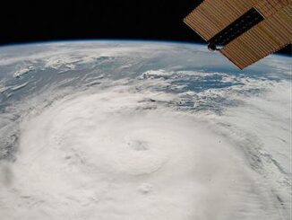
Featured image: Tropical Storm Henri headed north up the Eastern Seaboard, August 20, 2021 (Image courtesy NOAA)
© 2021, Environment News Service. All rights reserved. Content may be quoted only with proper attribution and a direct link to the original article. Full reproduction is prohibited.