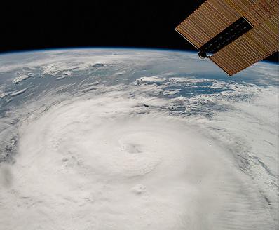
WASHINGTON, DC, December 7, 2020 (ENS) – The extremely active 2020 Atlantic hurricane season is finally over, after a record-breaking 30 named storms and 12 landfalling storms in the continental United States, breaking a record set in 1916. While the official hurricane season ended on November 30, tropical storms have continued to develop. All this unprecedented activity was stoked by a La Niña that developed this summer, says the National Weather Service.
In total, the 2020 season produced 30 named storms with top winds of 39 mph or greater, of which 13 became hurricanes with top winds of 74 mph or greater, including six major hurricanes with top winds of 111 mph or greater.
This is the most storms on record, surpassing the 28 from 2005, and the second-highest number of hurricanes on record. An average season has just 12 named storms, six hurricanes, and three major hurricanes.
The hurricanes and storms this season claimed an estimated 409 lives and caused more than $41 billion in property damage around the Atlantic Rim and across the Caribbean Sea.
The seasonal hurricane outlooks provided by the National Oceanic and Atmospheric Administration, NOAA, accurately predicted a high likelihood of an above-normal Atlantic hurricane season with a strong possibility of it being extremely active.
“Throughout this relentless hurricane season, NOAA worked around-the-clock to provide critical data and reliable forecasts to our nation’s communities in the path of devastating storms,” said U.S. Secretary of Commerce Wilbur Ross. “The services provided by NOAA, alongside our emergency management partners, undoubtedly helped save many lives and protect property.”
The 2020 season got off to an early and rapid pace with a record nine named storms from May through July, and then quickly exhausted the 21-name Atlantic list when Tropical Storm Wilfred formed on September 18.
For only the second time in history, the Greek alphabet was used for the remainder of the season, extending through the 9th name in the list, Iota.
“The 2020 Atlantic hurricane season ramped up quickly and broke records across the board,” said Neil Jacobs, PhD, acting NOAA administrator. “Our investments in research, forecast models, and computer technology allowed forecasters at the National Weather Service, and its National Hurricane Center, to issue forecasts with increasing accuracy, resulting in the advanced lead time needed to ensure that decision-makers and communities were ready and responsive.”
This is the fifth consecutive year with an above-normal Atlantic hurricane season, with 18 above-normal seasons out of the past 26.
This increased hurricane activity is attributed to the warm phase of the Atlantic Multi-Decadal Oscillation, AMO, which began in 1995. This has produced more, stronger, and longer-lasting storms since that time. Such active eras for Atlantic hurricanes have historically lasted about 25 to 40 years.
“As we correctly predicted, an interrelated set of atmospheric and oceanic conditions linked to the warm AMO were again present this year,” said Gerry Bell, PhD, lead seasonal hurricane forecaster at NOAA’s Climate Prediction Center. “These included warmer-than-average Atlantic sea surface temperatures and a stronger west African monsoon, along with much weaker vertical wind shear and wind patterns coming off of Africa that were more favorable for storm development. These conditions, combined with La Nina, helped make this record-breaking, extremely active hurricane season possible.”
This historic hurricane season saw record water levels in several locations, including the Gulf Coast where Hurricane Sally brought the highest observed water levels since Hurricane Katrina in 2005 to Pensacola, Florida. NOAA’s National Ocean Service stations recorded this data using the Coastal Inundation Dashboard, a tool to observe real-time water levels during a storm.
Scientists at NOAA’s Atlantic Oceanographic and Meteorological Laboratory and the Satellite Data and Information Service were able to get wave height information into the hands of forecasters using new instrumentation like the Ka-band Interferometric Altimeter. This vital oceanic data allowed forecasters to help mariners avoid dangerous situations at sea.
Additionally, three hurricanes – Isaias, Laura, and Sally – passed within range of NOAA’s hurricane ocean gliders this year, capturing invaluable ocean data below the storms while hurricane hunter planes captured atmospheric data above.
Capturing atmospheric data this season was no small feat, as forecasters and researchers relied on the heroic efforts of NOAA and U.S. Air Force Reserve Hurricane Hunters to provide invaluable data during this record-setting season.
There are no tropical cyclones in the Atlantic at this time, says the National Weather Service. The 2021 hurricane season will officially begin on June 1 and NOAA’s Climate Prediction Center will issue its first seasonal outlook in May.
Copyright Environment News Service (ENS) 2020. All rights reserved.
© 2020, Environment News Service. All rights reserved. Content may be quoted only with proper attribution and a direct link to the original article. Full reproduction is prohibited.