KYIV, Ukraine, April 18, 2020 (ENS) – A huge forest fire in Ukraine that blazed for more than 10 days came within one kilometer (.6 miles) of the defunct Chernobyl nuclear power plant and poses a continuing radiation risk, Greenpeace Russia warned on Monday, citing satellite images.
Greenpeace Russia tweeted, “Wildfires near the Chernobyl nuclear power plant burning since April 3 have already become the largest for the entire existence of this exclusion zone. These fires are dangerous because radionuclides located in the upper soil layers might be released into the air.”
Hundreds of firefighters and at least eight airborne units worked to extinguish fires in the Denysovets, Kotovsky, and Korogodsky forests. Fire damage also was reported in the surrounding Red Forest where many trees were killed.
Chernobyl is located about 100 km (62 miles) north of Ukraine’s capital city of Kyiv. The exclusion zone is an area of 2,600 km2 (1,000 square miles) around the nuclear power plant.
The nuclear plant itself, and the cities of Chernobyl and Pripyat survived the blaze, but one of the fires reached Pripyat, a town just a five-minute drive from the Chernobyl plant.
The largest fires were mostly extinguished by April 17, according to Ukraine’s Emergency Situations Service. A local resident, 27, was arrested for arson, Reuters reported. It is still unclear if the man, who has confessed to starting fires “for fun,” is responsible for the wildfires.
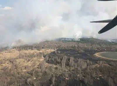
Aerial images of the 30 km (19 mile) exclusion zone around the plant, site of the world’s worst nuclear accident in 1986, showed scorched earth and the charred stumps of smoldering trees.
On April 26, 1986, the core of Reactor 4 exploded during a routine safety check at the Chernobyl Nuclear Power Plant, killing at least 30 people and releasing enormous amounts of radioactive material like corium, plutonium and uranium into the atmosphere.
According to the United Nations, nearly 20,000 square miles of land surrounding Chernobyl were contaminated.
In the months after the disaster, workers rushed to build a covering, or sarcophagus, to prevent the further spread of contaminants. That sarcophagus, built in haste, has been crumbling, and now it is nearing collapse.
Last month, the Ukrainian company that manages the Chernobyl plant concluded a US$78 million deal to tear down the structure, which is now surrounded by a 32,000-ton shell.
Today, a metal dome, unveiled in July 2019, encases the remains of Reactor 4 and the sarcophagus. The world’s largest moveable metal structure, the New Safe Confinement cost €1.5 billion (US$1.7 billion). It was paid for through a special fund launched by the European Bank for Reconstruction and Development, EBRD, and sponsored by 45 countries.
Weighing 36,000 tonnes, the structure is strong enough to withstand a tornado and is built to last a century, the EBRD said.
These protective structures would keep wildfires from touching the destroyed reactor, but the burning of the radioactive material deposited on the lands surrounding Chernobyl is the real concern now.
Citing evidence from satellite images, Greenpeace Russia said the situation is much worse than Ukrainian authorities believe, and that the fires cover an area 1,000 times bigger than they claim.

On April 6, “The Guardian” newspaper reported that radiation levels inside the exclusion zone were “16 times above normal” as a result of the fires.
While Ukranine’s Emergency Situations Service has said radiation levels in the exclusion zone had not changed and those in nearby Kyiv, the Ukrainian capital, “did not exceed natural background levels,” not everyone agrees.
IQAir reported that at one point on April 16, Kyiv had the worst air pollution in the entire world. However, the smoke has had little impact on the health of residents as it came during a lockdown due to the coronavirus pandemic, which meant most Kyiv residents were indoors at home.
As the fires spread, a small village near the mostly abandoned town of Poliske was evacuated on April 11. By April 13, the wildfires had spread to just over a mile away from the Chernobyl nuclear plant and had reached the outskirts of the abandoned city of Pripyat.
More than 300 firefighters struggled for more than a week to stop the fires from reaching the plant.
On April 14, the State Emergency Service of Ukraine said all large fires inside the exclusion zone had been extinguished after 10 days of firefighting efforts and recent rainfall in the region. The agency said it is still fighting the smaller fires, but that the situation is under control.
Yet, once radiation has entered the atmosphere on plumes of smoke, it can travel long distances, according to research published in 2016 in the journal “Nature” by an international team of scientists led by the Department of Atmospheric and Climate Research (ATMOS), of the Norwegian Institute for Air Research.
These scientists from Ukraine, Norway, France, the United Kingdom, and the United States found that the fires in contaminated areas can send radioactive elements into smoke plumes, that then travel long distances.
The European Space Agency’s Copernicus Sentinel-2 satellite mission has imaged the fires and smoke and mapped the resulting area of burned ground. The mission is being used as part of an activation of the Copernicus Emergency Management Service to provide maps of the burned area to help authorities respond to the consequences of this fire.
In parallel, the Copernicus Sentinel-3 mission also recorded the fires and the data is displayed in the Sentinel-3 World Fire Atlas Prototype.
Fires around Chernobyl occur seasonally, but the blazes have been worse than usual this year due to a mild winter and spring that have dried out the forest floor.
Copyright Environment News Service (ENS) 2020. All rights reserved.
© 2020, Environment News Service. All rights reserved. Content may be quoted only with proper attribution and a direct link to the original article. Full reproduction is prohibited.