MIAMI, Florida, November 16, 2020 (ENS) – The word iota means something very small, but the Category 5 Hurricane Iota now bearing down on Central America is the exact opposite. Expected to bring catastrophic winds, life-threatening storm surge, and torrential rainfall, it’s about to smash into Nicaragua and Honduras a few miles away from Puerto Cabezas, a Nicaraguan city of 100,000, where powerful Hurricane Eta made landfall just two weeks ago.
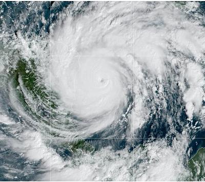
Iota reached Category 5 strength, the first storm of the season to achieve the highest ranking on the Saffir-Simpson Hurricane Wind Scale, when its winds peaked at 160 mph on Monday morning. Only hours earlier, Iota, the record-breaking, 30th named storm of the season had strengthened from a Category 2 storm to a Category 4 major hurricane within one hour.
The National Hurricane Center in Miami advised, “On the forecast track, the core of Iota will make landfall within the hurricane warning area in northeastern Nicaragua tonight, and dissipate over central America by Wednesday.”
Maximum sustained winds are near 160 mph (260 km/h) with higher gusts. Iota is forecast to continue to be a catastrophic category 5 hurricane when it approaches Central America tonight, and rapid weakening is expected after landfall.
AccuWeather meteorologist Jake Sojda warned, “The extremely dangerous hurricane could unleash the worst floods the region has had “in a thousand years or more” as it approaches in the midst of a humanitarian crisis triggered by Eta less than two weeks ago.”
A life-threatening storm surge will raise water levels by as much as 15 to 20 feet above normal tide levels in areas of onshore winds along the coast of Nicaragua and Honduras. Near the coast, the surge will be accompanied by large and destructive waves.
Catastrophic wind damage is expected where Iota’s eyewall moves onshore within the Hurricane Warning area in Nicaragua tonight with tropical storm conditions already ongoing. Hurricane conditions are likely on the island of Providencia for the next few hours.
Tropical storm conditions are expected in the Tropical Storm Warning area in Nicaragua and will begin in the Tropical Storm Warning area in Honduras tonight.
Hurricane Iota is expected to drop as much as 30 inches (750 mm) of rain through Thursday from northeast Nicaragua into northern Honduras, and 10 to 20 inches (250 to 500 mm) in Belize.
El Salvador and Panama could get as much as 15 inches (380 mm) in isolated areas, although the accumulation will be just six to 10 inches (150 to 250 mm) in most areas of these two countries.
These rainfall amounts are linked to life-threatening flash flooding and river flooding, along with mudslides in areas of higher terrain, the National Hurricane Center advises.
Southern Nicaragua and Costa Rica can expect three to five inches (75 to 125 mm) of rain, with isolated maximum totals of 10 inches (250 mm).
Swells generated by Hurricane Iota will affect much of the coast of Central America, the Yucatan Peninsula, Jamaica, and Colombia during the next couple of days. These swells are likely to cause life-threatening surf and rip current conditions.
Storm-weary residents of the northern Caribbean coast have been stocking in what candles, matches, food and personal items they can still find in the stores and seeking space in over-crowded shelters to prepare for the onslaught of yet another catastrophe.
The Nicaraguan government has been making preparations of its own. “Since yesterday the process of mobilization of all the families who are at high risk began, this morning we were informed that practically the entire population of Miskitos Cays has been mobilized, the mobilization of families and communities on the coast has accelerated and they are taking to places with infrastructure that will guarantee and withstand the forces of the winds that we are anticipating,” said Dr. Guillermo González, minister-director of the National System for Prevention and Attention to Disasters, SINAPRED.
“All the community networks were activated since yesterday,” he said, “with the house-to-house visits bringing information to the families in a precise way so that each family knows according to the place where they live what type of threat and danger they are exposed to and from there activate their community family plans.”
Copyright Environment News Service (ENS) 2020. All rights reserved.
© 2020, Environment News Service. All rights reserved. Content may be quoted only with proper attribution and a direct link to the original article. Full reproduction is prohibited.