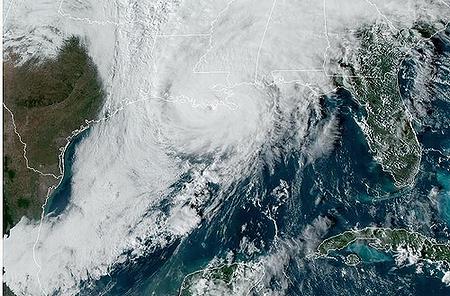
NEW ORLEANS, Louisiana, October 28, 2020 (ENS) – Hurricane Zeta has just made landfall as a 110 mile per hour, Category 2 hurricane near Cocodrie, Louisiana, a fishing, shrimping and crabbing village in Terrebonne Parish, due south of the city of Houma.
To reach Category 3, considered a major hurricane, Zeta’s sustained winds would have to exceed 111 mph on the Saffir-Simpson Hurricane Wind Scale. But forecasters expect plenty of damage anyway – storm surge, fierce winds, power outages and possible tornados.
National Weather Service meteorologist Lauren Nash says Zeta has had a stable path since Tuesday morning. “It really hasn’t shifted its track, and it looks like the eye will still pass just east of metro New Orleans,” Nash said.
Sandy beaches in Louisiana and Mississippi could be heavily damaged by Hurricane Zeta, according to the U.S. Geological Survey’s latest coastal change forecast. The USGS coastal change forecast can help emergency management officials decide which areas to evacuate, where and when to close coastal roads and where to position clean-up equipment ahead of the storm.
Louisiana and Mississippi are expected to bear the brunt of the storm’s strong waves and surge, with 12 percent of both states’ sandy beaches forecast to be inundated or continuously covered by ocean water. This is the most severe type of storm effect on coastal beaches, with flooding behind the dunes that may impact coastal communities.
The areas currently projected to be inundated are from Marsh Island, Louisiana, to Biloxi, Mississippi.
Sandy beaches in Texas, Alabama and Florida may see moderate to minor damage, forecasters say, but sandy beaches in those states are not projected to be inundated by Hurricane Zeta.

Reports from U.S. Air Force and NOAA Hurricane Hunter aircraft indicate that Zeta’s hurricane system continued to strengthen over the morning. Zeta is expected to maintain hurricane strength through landfall.
The National Hurricane Center in Miami predicts “a life-threatening storm surge” along portions of the northern Gulf Coast beginning later today, with the highest inundation occurring between Port Fourchon, Louisiana, and Dauphin Island, Alabama. Overtopping of local, non-federal levee systems is possible.
Hurricane conditions are expected this afternoon and evening within portions of the Hurricane Warning area along the southeastern Louisiana and Mississippi coasts.
Tropical storm conditions are expected within portions of the Tropical Storm Warning area along the Alabama and far western Florida Panhandle coasts.
Strong, damaging wind gusts, which could cause tree damage and power outages, will spread well inland across portions of southeastern Mississippi, Alabama, northern Georgia, the Carolinas, and southeastern Virginia tonight and Thursday due to Zeta’s fast forward speed.
Areas of heavy rainfall, both in advance of and along the track of Zeta, will impact areas from the central Gulf Coast to the Mid-Mississippi and Ohio Valleys, and eastward into the southern to central Appalachians and Mid-Atlantic where wind gusts could be especially severe today through Thursday.
Rainfall totals of two to four inches with isolated amounts of six inches are expected across these areas, resulting in flash floods, as well as urban, small stream, and minor river flooding.
Back in Louisiana, President Donald Trump has approved Governor John Bel Edwards’ request for federal assistance related to Hurricane Zeta.
Governor Edwards said, “This assistance will be critical in responding to this hurricane, assisting local governments and beginning our long-term recovery efforts. Louisiana has faced an incredibly active hurricane season this year, and we have been working in partnership with the federal government and local officials since March on the response to the pandemic in addition to two major hurricanes in Southwest Louisiana.”
Hurricane Zeta is the third hurricane to make landfall in Louisiana in two months, following hurricanes Laura in late August, which killed 77 people and caused $14.1 billion in damages; and Delta in early October, a Category 4 hurricane that claimed six lives and caused $2 billion worth of damage in the United States and the Caribbean.
It is the fifth named storm of 2020 to hit the state of Louisiana, joining Cristobal, Laura, Marco and Delta. It is already the ninth named storm that will have entered or formed in the Gulf.
Mandatory evacuations have been ordered for three parishes in Louisiana:
* – Jefferson Parish, where a mandatory evacuation order was issued for Grand Isle at noon Tuesday. Mandatory evacuations were also issued for the towns of Jean Lafitte, Lower Lafitte, Crown Point and Barataria.
* – Lafourche Parish, where all residents and businesses south of the Leon Theriot Floodgate and other low-lying areas in the parish are under a mandatory evacuation order as of 6 a.m. Wednesday.
* – Terrebonne Parish, where mandatory evacuations are ordered for residents south of the Morganza to the Gulf levee system as of 10 a.m. Wednesday.
And in Mississippi’s Hancock County, mandatory evacuations are ordered for all low-lying areas.
In all other low-lying, flood-prone areas of the Alabama, Louisiana and Mississippi coasts voluntary evacuations were recommended by the state emergency management agencies.
Copyright Environment News Service (ENS) 2020. All rights reserved.
© 2020, Environment News Service. All rights reserved. Content may be quoted only with proper attribution and a direct link to the original article. Full reproduction is prohibited.