
WASHINGTON, DC, April 9, 2016 (ENS) – Freshwater polluted by harmful algal blooms costs the United States at least $64 million every year, by government estimates.
Now four federal agencies are collaborating on a $3.6 million research project to transform satellite data into information in formats that managers can use to protect human health and the environment from harmful algal blooms.
The four agencies – U.S. Environmental Protection Agency, the National Aeronautics and Space Administration, the National Oceanic and Atmospheric Administration and the U.S. Geological Survey – are developing a method that will detect and measure the harmful algal blooms in freshwater systems by satellite.
This satellite data will go to support the environmental management and public use of U.S. lakes and reservoirs.
Ocean color satellite data are currently available to scientists, but are not routinely processed and produced in formats that help state and local environmental and water quality managers.
Through this project, satellite data on harmful algal blooms developed by the four partner agencies will be converted to a format that stakeholders can use through mobile devices and web portals.
“The vantage point of space not only contributes to a better understanding of our home planet, it helps improve lives around the world,” said NASA Administrator Maj. Gen. Charles Frank Bolden, Jr. “We’re excited to be putting NASA’s expertise in space and scientific exploration to work protecting public health and safety.”
Cyanobacteria are a genetically diverse group of photosynthetic microorganisms – formerly known as blue-green algae – that occupy a broad range of habitats on land and water all over the world.
If the water is full of excessive nutrients from fertilizers and manure, cyanobacteria rapidly multiply to create a cyanobacterial harmful algal bloom, or cyanoHAB.
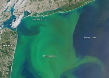
When conditions are right, the growth of microscopic phytoplankton can blossom to scales that are visible from space for weeks.
Some cyanobacteria produce toxins that can kill wildlife and domestic animals and cause illness or death in humans
People and animals get sick through exposure to contaminated freshwater or by the consumption of contaminated drinking water, fish or shellfish.
In August 2014, officials in the city of Toledo, Ohio, banned the use of their regular source of drinking water supplied to more than 400,000 residents after it was contaminated by an algal bloom in Lake Erie.

But cyanoHABs are not just an American problem; they’re a worldwide expensive and unpredictable public health threat that can affect millions of people.
“Harmful algal blooms have emerged as a significant public health and economic issue that requires extensive scientific investigation,” said USGS Director Suzette Kimball. “USGS uses converging lines of evidence from ground to space to assess changes in water quantity and quality, ecosystems, natural hazards, and environmental health issues important to the nation.”
CyanoHABs are a product of a complex set of natural and human influences that make it challenging to provide early warning for public health protection and to minimize socioeconomic impact.
Rapid detection of potentially harmful blooms is essential to protect humans and animals from exposure. Development of a scientifically robust, systematic identification of CyanoHAB events is key to achieving an early-warning capability and to focus field resources more efficiently.
NOAA and NASA pioneered the use of satellite data to monitor and forecast harmful algal blooms. Satellites allow for more frequent observations over broader areas than water sampling.
Satellite data support NOAA’s existing forecasting systems in the Gulf of Mexico and Great Lakes.
Through this project, satellite data on harmful algal blooms developed by the partner agencies will be enhanced by coupling satellite data with field measurements of cyanotoxins and pigments associated with cyanobacteria that can be translated to cyanobacteria abundance.
The combination of field measurements and remotely sensed data allows for the development of nationally consistent, physically based models that can be converted to a format that stakeholders can use through mobile devices and web portals.
Satellite remote sensing tools may enable policy makers and environmental managers to develop early-warning indicators of cyanobacteria blooms at the local scale while maintaining continuous national coverage.
“Algal blooms pose an expensive, unpredictable public health threat that can affect millions of people,” said Sarah Ryker, USGS deputy associate director for climate and land use change. “By using satellite-based science instruments to assess conditions in water and on adjacent land, we hope to improve detection of these blooms and to better understand the conditions under which they occur.”
The Landsat satellite series, a joint effort of USGS and NASA, has provided a continuous dataset of land use and land cover conditions since 1972. The latest satellite, Landsat 8, has demonstrated promising new capabilities for water quality assessment.
Copyright Environment News Service (ENS) 2016. All rights reserved.
© 2016, Environment News Service. All rights reserved. Content may be quoted only with proper attribution and a direct link to the original article. Full reproduction is prohibited.