By Charles Mkoka
LILONGWE, Malawi, November 2, 2015 (ENS) – This year, Malawi experienced exceptionally heavy rains that led to serious flooding in 15 districts. Villages, homes, crops and property were destroyed and lives and livestock lost in this landlocked country in southeast Africa.
To help communities be prepared if another devastating deluge strikes, the Machinga and Chikwawa Districts in southern Malawi have a new program.

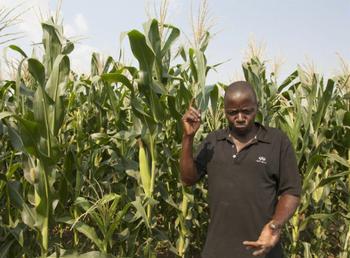
“We have developed a map for our area in which we have indicated key important challenges. We have also pointed out what is prone to disaster and marked it with a red star. We find out the causes of these disasters and how we can mitigate them,” said Jack Issa of Kampani Village Civil Protection Committee, under Group Village Headman Mkumbira, Traditional Authority Chikweo.
Issa said that to effectively combat the impact of climate change, the Village Civil Protection Committees, VCPCs must focus on disaster preparedness, emergency response and recovery.
“As a part of preparedness, we have been planting trees along river banks and moving people from flood-prone areas,” he said.
The Kampani VCPC will work with the school committee, local churches and community-based organisations to reach as many residents as possible when floods are imminent, said Issa. Disabled people affected by disasters will be accounted for, he explained.
The Kampani VCPC is supported by Emmanuel International, a partner in the Enhancing Community Resilience Programme, ECRP, a five-year program funded by UK aid, Irish Aid and the Norwegian Ministry of Foreign Affairs. It is run by a consortium led by international development agency Christian Aid, with CARE International, Action Aid and 10 implementing partners.
When disasters strike, VCPCs assess how many people have been affected, the loss of livestock and damage to property and crops.
This information is then sent to Area Civil Protection Committees, ACPCs, and then on to the district disaster office. The district office uses the information to determine how many households might face food insecurity, better plan future humanitarian assistance and provide advice on which crops to grow.

George Mkwaila, who chairs the Chikweo ACPC, explained how community members have also been trained as first responders to rescue people when disasters strike.
In Chikwawa, VCPC member Alex Mchacha said budgeted contingency plans are being developed at village level. These plans ensure the committee has enough flour to provide porridge for those affected by floods while they wait for other assistance.
The Village Civil Protection Committee also checks houses and other structures to determine if they can withstand shocks and will not be dangerous during strong winds and heavy rains.
Early warning systems are also a key pillar of the Enhancing Community Resilience Programme, providing timely and relevant information that allows those in danger to take action to avoid or reduce the risk of harm or losses and prepare for an effective response.
Meteorologist Josta Mahalu explained that under ECRP, four centers have been equipped with rain gauges to observe rainfall trends.
Information from these centers about the residual moisture present in the soil helps farmers to plan the planting of their crops and which varieties of maize, tobacco or groundnuts to acquire. They also use this information to predict the amount of water that can be expected in their irrigation schemes.
ECRP communities receive this information through Esoko, an African agricultural information and communication service that provides market information, weather forecasts and growing tips.
“Text messages sent through Esoko to small scale farmers helps in reporting localized weather information,” said Chakhumata Yokoniya, chair of the VCPC in Group Village Headman Khungubwe, Traditional Authority Ngowe.
“Once we get these messages from weather experts we mobilize the farmers using a public address system to alert them of impending weather. The information also arms those doing conservation agriculture. It is crucial in decision making on what type of seed and varieties should be planted as part of resilience building and food security,” said Yokoniya.

In Chikwawa, a district prone to flooding because the terrain is flat, people have pinpointed the Lalanje River, which marks the boundary between Chikwawa and Nsanje, as a major threat during times of disasters.
Local VCPCs, whose capacity has been built through the Enhancing Community Resilience Programme, worked together to create a sandbag barrier to prevent flooding waters from reaching their villages.
But this work is not without its challenges. A water measuring gauge that warns farmers upland to inform others downstream of swelling water level was apparently buried with soil during construction of the Nchalo-Nsanje road and remains hidden today.
Broken mobile phones have also presented challenges to early warning systems, as Esoko weather alerts cannot then reach the people who need them most.
The Enhancing Community Resilience Programme feeds into the broader context of the New Partnership for African Development, Comprehensive African Agriculture Development Programme, to ensure food security and spur economic development on the African continent.
In addition, Malawi’s first ever Resilience Innovation Lab has successfully secured support from the United Nations Development Programme, and will be financially supported by the Government of Denmark. This lab will serve as an incubator of new and innovative ideas in building resilience against environmental and economic shocks in Malawi.
Copyright Environment News Service (ENS) 2015. All rights reserved.
© 2015, Environment News Service. All rights reserved. Content may be quoted only with proper attribution and a direct link to the original article. Full reproduction is prohibited.
