NEW YORK, New York, August 4, 2020 (ENS) – Tropical Storm Isaias is racing north-northeastward across eastern New York near the state’s capital city Albany, carrying strong gusty winds, heavy rainfall and the threat of tornadoes, according to the National Weather Service. The tropical storm is moving about 20 miles per hour bearing maximum sustained winds of 65 mph.
Tropical Storm Isaias claimed at least one life in New York City on Tuesday and critically injured another person, authorities said.
A man was killed in Queens when a tree broken by powerful winds smashed his car Tuesday afternoon and in Brooklyn a woman was critically injured by a flying branch, officials said.

In a radio interview Tuesday after the death, New York Mayor Bill de Blasio urged New Yorkers to stay indoors to avoid injury or even death.
“It’s so sad we lost someone in Queens now from a falling tree branch and I just want to let all New Yorkers know we’ve got to take this storm seriously, it is a dangerous level of high winds,” de Blasio said.
Tropical Storm Isaias has knocked out power in Brooklyn, Queens and Staten Island. A building that collapsed on Bedford Avenue in the Williamsburg section of Brooklyn buried a car but no one was injured.
Transit officials shut down service on all Metro-North Railroad and Long Island Railroad lines due to a “substantial amount of damage from downed trees down utility poles,” according to Metropolitan Transportation Authority chairman Pat Foye, who said, “Largely the problem in this storm is high winds and downed trees.”
The Metropolitan Transportation Authority has banned tandem trailers and empty tractor-trailers on its bridges from noon to midnight on Tuesday.
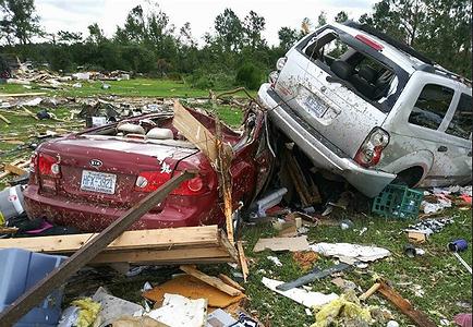
After making landfall as a Category 1 hurricane near Ocean Isle Beach, North Carolina just after 11 pm on Monday with maximum sustained winds of 85 mph, Isaias weakened to a tropical storm. But the danger had not passed. A tornado spawned by Tropical Storm Isaias killed two people Tuesday morning in a Bertie County mobile home park, local North Carolina officials said. At least 12 injured people were taken to hospital.
Moving north, Isaias brought dangerous winds and heavy rain to eastern Virginia early Tuesday.
Its top winds dropped to 70 miles per hour by early Tuesday, and gradual weakening is expected this afternoon and evening, followed by a faster rate of weakening tonight, according to the National Hurricane Center. Isaias is forecast to become post-tropical tonight or early Wednesday.

At this time, tropical-storm-force winds extend outward up to 205 miles from Isaias’ center. During the past hour, a NOAA NOS observing site at Sandy Hook, New Jersey, reported a sustained wind 41 mph and a gust to 50 mph. Wind gusts in excess of 50 mph have also been reported at multiple sites in southeastern New York, Connecticut, Rhode Island, and Massachusetts this afternoon.
Isaias will continue moving north-northeastward through tonight, accompanied by a gradual decrease in forward speed. In 12 hours or, the cyclone is expected to interact with a larger extratropical over southeastern Canada and degenerate into a post-tropical cyclone near western Maine. By 24 hours, Isaias is expected to transition to an extratropical low, and dissipate, forecasters say.
Tropical storm conditions are expected to reach southern New England by late afternoon and reach northern New England tonight.
Gale-force winds are expected to spread into southeastern Quebec tonight and Wednesday.
Widespread tropical-storm conditions are expected in the tropical storm warning area in eastern New York, Long Island, and southern New England, with wind gusts to hurricane force possible. These winds could cause significant tree damage and power outages, forecasters warn.
STORM SURGE: The combination of storm surge and the tide will cause normally dry areas near the coast to be flooded by rising waters moving inland from the shoreline. If the peak surge occurs at the time of high tide, the water could reach 1-2 feet from Sandy Hook, New Jersey to Martha’s Vineyard, Massachusetts, including Long Island Sound, Block Island Sound, Narragansett Bay, Buzzards Bay, and Vineyard Sound.
RAINFALL: The following rainfall accumulations are expected along and near the track of Isaias:
Eastern New York into Vermont: 2 to 4 inches, isolated maximum totals 6 inches.
Western Connecticut, western Massachusetts, New Hampshire and western Maine: 1 to 3 inches. Southern Quebec: 1 to 3 inches.
Heavy rainfall near the path of Isaias, through the Hudson River Valley, is likely to result in flash flooding, particularly through urban areas and the surrounding terrain of the Catskills, Adirondack and Green Mountain Ranges through Tuesday night. Scattered minor to moderate river flooding is likely across portions of the Mid-Atlantic. Quick-responding rivers in the Northeast will also be susceptible to minor and possible moderate river flooding.
TORNADOES: A couple of tornadoes are possible across southern New England late this afternoon. A risk for tornadoes may continue and spread across parts of northern New England through this evening.
SURF: Swells generated by Isaias will spread northward along the mid-Atlantic and Northeast coasts of the United States today. These swells are likely to cause life-threatening surf and rip current conditions.
Right now, the Red Cross has staff members on standby to open 10 shelters across the region – New York City, Long Island, Rockland and Westchester counties and Greenwich, Connecticut. These teams are trained to provide comfort and care to evacuated and displaced residents while taking into account new safety protocols necessitated by COVID-19.
As soon as the storm passes, Red Cross Disaster Assessment volunteers will canvas areas prone to flooding, survey damage of the most affected communities, make contact with residents and, if needed, begin coordinating assistance, including the distribution of relief supplies.
The Red Cross is seeking new volunteers for their Red Cross Hurricane Reserve Corps, a new, trained group of team members ready to support affected communities in the event of a major disaster.
This large number of local “reserve” volunteers is needed due to the added constraints brought on by COVID-19, difficulty in bringing volunteers from other parts of the country and the projected intensity of the 2020 Atlantic Hurricane Season.
The Atlantic Hurricane Season runs from June 1 to November 30, 2020, with its peak in the Northeast in August and September. To join, visit redcross.org/volunteertoday and scroll down to find the “Shelter” or “Health Services” roles. Training for these new volunteers will be conducted online.
The New York Department of Transportation advises:
DO NOT attempt to drive over a flooded road. Turn around and go another way.
DO NOT underestimate the destructive power of fast-moving water. Two feet of fast-moving flood water will float your car. Water moving at two miles per hour can sweep cars off a road or bridge.
Watch for washed-out roads, earth-slides, broken water or sewer mains, loose or downed electrical wires, and falling or fallen objects.
Copyright Environment News Service (ENS) 2020. All rights reserved.
© 2020, Environment News Service. All rights reserved. Content may be quoted only with proper attribution and a direct link to the original article. Full reproduction is prohibited.
