
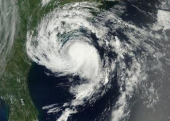
COLLEGE PARK, Maryland, June 1, 2015 (ENS) – The 2015 hurricane season officially opened on Monday as U.S. weather forecasters predicted a “below-normal” risk of hurricanes in the Atlantic and “above-normal” risk in the Pacific.
“But that’s no reason to believe coastal areas will have it easy,” said the National Oceanic and Atmospheric Administration’s National Hurricane Center in its annual prediction.
While NOAA forecasters are calling for a 70 percent likelihood of a below-normal season in the Atlantic, there is also a 20 percent chance of a near-normal season, and a 10 percent chance of an above-normal hurricane season.
NOAA is predicting a 70 percent likelihood of six to 11 named Atlantic storms with winds of 39 mph or higher, of which three to six could become hurricanes with winds of 74 mph or higher.
The prediction is for up to two major Atlantic hurricanes of Category 3, 4 or 5 strength with winds of 111 miles per hour or higher.
“A below-normal season doesn’t mean we’re off the hook. As we’ve seen before, below-normal seasons can still produce catastrophic impacts to communities,” said NOAA Administrator Dr. Kathryn Sullivan. She was referring to the 1992 season in which only seven named storms formed, yet the first was Andrew, a Category 5 major hurricane that devastated South Florida.
“The main factor expected to suppress the hurricane season this year is El Niño, which is already affecting wind and pressure patterns, and is forecast to last through the hurricane season,” said Gerry Bell, Ph.D., lead seasonal hurricane forecaster with NOAA’s Climate Prediction Center.
NOAA will issue an updated outlook for the Atlantic hurricane season in early August, just before the historical peak of the season.
“El Niño may also intensify as the season progresses, and is expected to have its greatest influence during the peak months of the season,” said Bell. “We also expect sea surface temperatures in the tropical Atlantic to be close to normal, whereas warmer waters would have supported storm development.”

The Eastern Pacific and Central Pacific will have above-normal risk of hurricanes, NOAA predicts, also based on the presence of El Niño, a band of warm ocean water that develops off the Pacific coast of South America.
For the Eastern Pacific hurricane basin, NOAA’s 2015 outlook is for a 70 percent probability of 15 to 22 named storms, of which seven to 12 are expected to become hurricanes, including five to eight major hurricanes.
For the Central Pacific hurricane basin, NOAA’s outlook is for a 70 percent chance of an above-normal season with five to eight tropical cyclones likely.
“It only takes one hurricane or tropical storm making landfall in your community to significantly disrupt your life,” said FEMA Deputy Administrator Joseph Nimmich. “Everyone should take action now to prepare themselves and their families for hurricanes and powerful storms.”
“Develop a family communications plan, build an emergency supply kit for your home, and take time to learn evacuation routes for your area,” Nimmich advised. “Knowing what to do ahead of time can literally save your life and help you bounce back stronger and faster should disaster strike in your area.”
With the new hurricane season comes a new prototype storm surge watch and warning graphic from NOAA’s National Hurricane Center.
The graphic will highlight areas along the Gulf and Atlantic coasts of the United States at risk of life-threatening inundation by storm surge during a tropical cyclone.
Storm surge is often the greatest threat to life and property from a tropical cyclone, and it can occur at different times and at different locations from a storm’s hazardous winds. In addition, while most coastal residents can remain in their homes and be safe from a tropical cyclone’s winds, evacuations are often needed to keep people safe from storm surge.
Having separate warnings for these two hazards should provide emergency managers, the media, and the general public better guidance on the hazards they face when tropical cyclones threaten.
Also new this season is a higher resolution version (two kilometers near the storm area) of NOAA’s Hurricane Weather Research and Forecasting model, HWRF.
The new HWRF data assimilation system will make better use of aircraft reconnaissance-based Tail Doppler Radar data for a five percent improvement in the intensity forecasts compared to last year.
Copyright Environment News Service (ENS) 2015. All rights reserved.
© 2015, Environment News Service. All rights reserved. Content may be quoted only with proper attribution and a direct link to the original article. Full reproduction is prohibited.