SAO PAULO, Brazil, August 27, 2021 (ENS) – Brazil has lost 15 percent of its surface water in the past 30 years, finds a comprehensive analysis published on the new MapBiomas Water Platform. The extent of this water loss is so disturbing in a warming world that the global conservation organization WWF calls the report “alarming” and “shocking.”
MapBiomas is an initiative of the Greenhouse Gas Emissions Estimation System, or SEEG, created by the Climate Observatory, a Brazilian network of nongovernmental organizations, NGOs. The MapBiomas analysis revealing the water loss wasproduced by its own collaborative network of co-creators made up of NGOs, universities and technology companies organized by biomes and cross-cutting themes.
“Changes in land use and coverage, construction of dams and hydroelectric plants, excessive use of water resources for the production of goods and services have altered the quality and availability of water in all Brazilian biomes,” Carlos Souza, coordinator of the Water Working Group at the MapBiomas project, said.
Biomes are large communities of vegetation and wildlife adapted to a specific climate – in Brazil the biomes are places like the Amazon, the Atlantic Forest, and the Pantanal wetlands, among others.
Coordination of the information on biomes was handled by a different scientific group, or pair of groups, for each one.
Amazon – Institute of People and Environment of the Amazon (IMAZON)
Caatinga – Feira de Santana State University (UEFS), Northeast Plants Association (APNE) e GeoDatin
Cerrado – Amazon Environmental Research Institute (IPAM)
Atlantic Forest – SOS Mata Atlantica Foundation and ArcPlan
Pampa – Federal University of Rio Grande do Sul (UFRGS) and GeoKarten
Pantanal – SOS Pantanal Institute and ArcPlan
Cross-cutting Themes Coordination:
Pasture – Federal University of Goiás
Agriculture – Agrosatelite
Coastal Zone and Mining – Vale Technological Institute / Solved
Urban Areas– University of São Paulo, Federal University of Bahia and Federal University of São Carlos
Google is among MapBiomas’ technology partners. For a full list of MapBiomas participants, click here.
The MapBiomas Water series processed more than 150,000 images generated from 1985 to 2020 by the satellites Landsat 5, 7 and 8, a joint program of the U.S. National Aeronautics and Space Administration, NASA, and the U.S. Geological Survey, USGS.
With the help of artificial intelligence, the area covered by water in each pixel of 30 meters X 30 m of the more than 8.5 million square kilometers of Brazilian territory was analyzed over the 36 years between 1985 and 2020, distinguishing natural and human-made water bodies.
In all, 108 terabytes of images were processed, revealing areas, years and months of greater and lesser water coverage.
All data, maps, methods and codes of MapBiomas are made available publicly and free of charge on the initiative’s website: mapbiomas.org
So, Where’s the Water?
Gathering data from all these sources, the analysis found that overall, across all biomes, Brazil’s surface water extent dwindled from 19.7 million hectares in 1991 to 16.6 million hectares in 2020.
The Negro River, one of the largest tributaries of the Amazon and one of the world’s 10 largest rivers by average discharge, has lost 22 percent of its surface water.
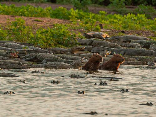
The Brazilian section of the Pantanal, the world’s largest tropical wetland, inhabited by a rich variety of wildlife, has lost 74 percent of its surface water, the MapBiomas Water Platform shows.
Some of the greatest losses are close to agricultural zones, which indicates that increased water consumption and the construction of small farm dams that fragment the drainage network, are contributing to the loss of natural surface water in Brazil.
“These dams are adding to an agricultural model that already alters the water drainage regime and intensifies the deposition of sediments, reducing the flow of water. If this development model is not revised, the future Pantanal is compromised,” said Cássio Bernardino, WWF-Brazil, which has partnered with MapBiomas network and the Imazon NGO on the analysis.
The loss of nearly three-quarters of the Brazilian Pantanal’s natural surface water is bound to have a major impact on river flows and water dynamics – and on all the people and over 4000 species that depend on them.
“Hydropower plants have contributed to the losses and yet,” WWF warns, “there are still dozens of other hydropower dams on the drawing board for this region – dams that will generate negligible amounts of power, while having significant social and environmental impacts.”
Other obvious causes of water loss are deforestation and rising temperatures due to climate change.
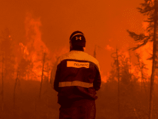
A link between wildfires and the reduction in surface water is evident in some areas such as in the town of Corumba in Mato Grosso do Sul, which has endured the most fires and lost the most surface water between 1985 and 2021.
“The fire and water cycles are interconnected. Less water makes the earth and the organic matter that settles on it more vulnerable to fire. More fire suppresses the vegetation, which plays a crucial role in perpetuating springs,” explained Tasso Azevedo, coordinator of MapBiomas.
The São Francisco River, one of Brazil’s largest, has lost 10 percent of its surface water over the past 15 years, during a period of agricultural expansion in the region. At the mouth of the São Francisco, communities are now seeing salt water from the Atlantic Ocean intruding farther up the river.
Across Brazil’s vast Cerrado savanna, critical for agricultural production and filled with many unique and diverse species, the water system is being transformed. Natural surface water has fallen nearly by half from 864,000 hectares to just 490,000 hectares. Much more surface water is now governed by hydropower, changing water flows and impacting people and nature.
“This new data is a clear warning sign,” Bernardino says. “Brazil needs to take urgent action to safeguard its priceless water resources. Other countries should also take note. They need to sustainably conserve and manage their freshwater ecosystems in the face of growing pressures, including the worsening impacts of our warming world.”
Click here to read the scientific publication: Souza at. al. (2020) – Reconstructing Three Decades of Land Use and Land Cover Changes in Brazilian Biomes with Landsat Archive and Earth Engine – Remote Sensing, Volume 12, Issue 17, 10.3390/rs12172735.
Featured image: Wildfire in the Brazilian Pantanal in the state of Mato Grosso do Sul, August 2020. (Photo © Silas Ismael / WWF-Brasil)